Access planning
Site & Access Layout
Help with access roads, landings, staging areas, and equipment paths that respect terrain, soils, drainage,
and the landowner’s constraints.
We plan routes and landings from LiDAR terrain and drainage data, GIS
layers, and elevation modeling, not a walk-through and a guess. That's how
we catch a grade that won't hold equipment or a low spot that turns into a
mud pit in spring, before it costs you a rebuilt landing or a stuck skidder.
- LiDAR-based access and drainage feasibility review
- Landing and staging placement backed by terrain data
- GIS-mapped slope and soil constraints before machines mobilize
- On-the-ground walk-through to confirm what the data shows
Habitat-sensitive clearing
Clearing & Habitat-Sensitive Work
Plans that balance what the project needs with what the landowner wants left standing. Especially around cabins, camps, rural builds, and long-term stewardship goals.
Owners are often more particular about what stays than what goes. A single
legacy oak or a screen of pine along a sightline can matter more to them than
the rest of the clearing combined. We flag that up front so it doesn't turn
into a conversation on-site.
- Define leave tree and protection zones clearly
- Edge control, screening, and sightline logic
- Work sequencing that avoids unnecessary damage
- Practical expectations owners can understand
Owner coordination
Owner-Facing Support
We can walk the ground with the client, translate tradeoffs into plain English,
and help set expectations so your crews can just get to work.
Most friction on these jobs doesn't come from the work itself. It comes from
an owner who doesn't understand why a decision was made. A walk-through before
the first day on-site heads off a lot of that.
- Pre-mobilization walk-through with owner + contractor
- Clarify constraints before they turn into conflict
- Document “what matters” so the field team is protected
- Help avoid scope drift and surprise objections
Mapping & data
Mapping & Decision Support
Mapping is a tool, not the product. We use LiDAR and GIS data to reduce
guesswork on expensive decisions: access placement, staging, drainage risk,
and how the terrain will behave once disturbed.
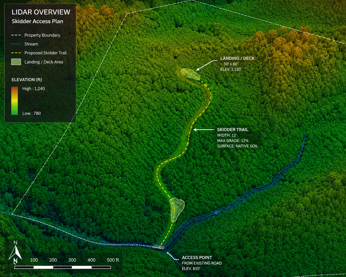
That might be a LiDAR-based access plan like the one above, a GIS terrain
and drainage review before you commit to a route, or a quick constraint
check on a parcel you haven't walked yet. We're not trying to replace
survey or engineering work, just fill the gap before it's needed with data
instead of a guess.
- LiDAR and GIS terrain review tied to field reality
- Constraint spotting before work begins
- Data-backed support for access and layout decisions
- Not a substitute for survey or engineering work